
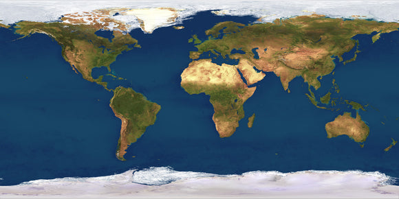
World Satellite 4 km resolution
The satellite image of the world at 4 km per pixel resolution gives an image 10,800 pixels wide by 5400 pixels high giving an image 72 inches wide at 150 dpi. The uncompressed file size is 42 MB, Projection is defined as Plate Carree/ Geographical / Linear.
The satellite systems used offer frequent global coverage, but do not acquire images in true colour. To simulate natural colours over the land, red and near-infrared wavelengths are used to differentiate land cover types on the basis of their spectral reflectance characteristics. Ground-level, aerial and orbital photography are then used to assign red, green and blue colour values to known feature types, giving realistic land surface colour for anywhere in the world.
Ocean color is derived from a combination of ocean depth and ocean chlorophyll observations. Polar areas covered by sea ice are derived from individual optical images. On land, the courses of rivers are merged in from a digital map database and the appearanceof physical features has been enhanced by hill-shading using a digital terrain model.